Maps of the Island
In partnership with UPEI’s The Island Imagined website, many maps from the Prince Edward Island Museum and Heritage Foundation’s collection have been digitized for the public to enjoy. Detailed and intricate, the work of cartographers can reveal much about the social and physical changes of Prince Edward Island over time. Maps and atlases allow for us to understand the development, and story, of Canada’s smallest province on a deep, visual level.
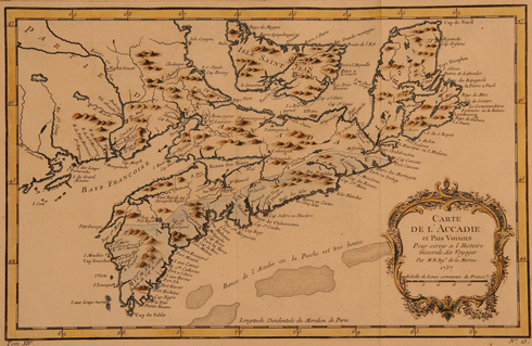
For many years after the arrival of European explorer Jacques Cartier in 1534, depictions of the island on maps were often distorted. The land was depicted in different shapes, sizes, and locations. One example is a map of “L’Accadie” (Fig. 1) from 1757, including Nova Scotia, Prince Edward Island, Cape Breton, and part of New Brunswick with all place names in French. On this particular map, Isle Saint Jean (Prince Edward Island) is only beginning to show the telltale crescent shape that we know it to have today. The left-hand side stops at present-day Bedeque and Malpeque, and the area of Summerside to Tignish is completely left off. On the right-hand side, the island is cut off close to modern-day Souris.

In 1763, Prince Edward Island was transferred from French to British sovereignty after the Treaty of Paris. Under British administration, the name of the island was anglicized to St. John’s Island, and Dutch surveyor Samuel Holland was given permission to do a survey of the landmass one year later. By 1765, Holland had created a map that would change the future of the colony permanently. The map came together thanks to the work of four survey parties, named after each lead surveyor; Holland, Haldimand, Wright, and Robinson. The parties were small, including only the lead surveyor, three soldiers, and a seaman from the ship they arrived on. There is evidence that at least three of the four parties included an Acadian guide.
Holland’s map would be the first to depict Prince Edward Island in an accurate form. It also indicated more than 200 bays, points, rivers, capes and coves in the land. Yet, perhaps most importantly, it divided the colony into 67 townships or “lots” of 20,000 acres each, and 14 parishes. Many of those lots were granted to British military officers, or others who the government owed favours to.

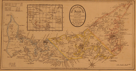
The very first map featuring the name “Prince Edward Island” was created by cartographer H. Ashby in the late 1700s. It shows the island divided into parishes, counties, and lots (as created by Samuel Holland.) Lot owners were expected to send settlers to the colony to fulfill the expectations of their grant, but very few did. That led to a large amount of undeveloped land, along with steep rent and purchase fees for those looking to own land on the island. The issue of land ownership became one of the most notable topics of debate up until the time of Confederation.

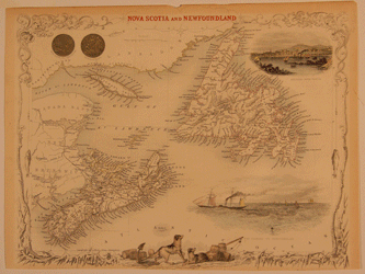
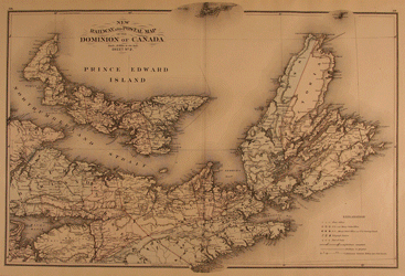
The quality of maps would continue to improve throughout the 1800’s. On a “Nova Scotia and Newfoundland” map published in 1851 (Fig. 3), Newfoundland, Nova Scotia, Prince Edward Island, the Magdalen Islands, Anticosti Island, and parts of New Brunswick and Quebec are shown in great detail. The shape and location of Prince Edward Island is very similar to what is seen on a modern map today. Another interesting example of map advancement is the “New Railway and Postal Map of the Dominion of Canada,” (Fig. 4) created in 1880. It shows Prince Edward Island, Nova Scotia and Cape Breton, and a small part of New Brunswick. Considering that the Prince Edward Island Railway only ran its first regularly scheduled passenger train across the island in 1875, the railroad was still quite new at the time of this map’s creation. A bold black line across the province indicates the tracks running from Tignish to Souris; connecting the people of Prince Edward Island in a new and revolutionary way. The map also includes markers for the post offices, money order offices, P.O. saving offices, telegraph sections, ports of entry, and distance between towns over post roads of the time. A close look will show a patchwork of post offices that were established by that time in most communities.

To look at the rich digitized map collection of the PEI Museum and Heritage Foundation is to engage with the past in a unique way. More than a picture, the maps show the true landscape of the province over time.
To access the Foundation’s maps, explore the Island Imagined website